Aerial photographs of Worthing in the Second World War made public for the first time

and live on Freeview channel 276
The photographs were taken by the United States Army Air Forces (USAAF) Photographic Reconnaissance (PR) units stationed at bases around the country in 1943 and 1944.
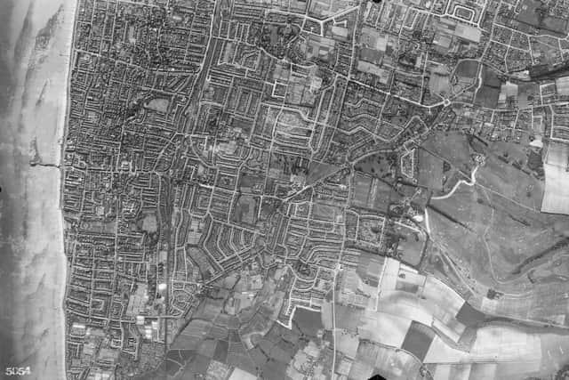
More than 3,600 black and white images showing England from the air are available in a free online, searchable map. The remarkable collection gives a bird’s-eye view of the impact of war on England, capturing a wide variety of locations and an astonishing level of detail.
Advertisement
Hide AdAdvertisement
Hide AdThey offer a unique view of England as it changed during the Second World War – capturing ancient monuments surrounded by anti-tank defences in West Sussex, airfields with American bombers and baseball players in Wiltshire and bomb damage to towns and cities like Old Trafford football stadium in Greater Manchester.

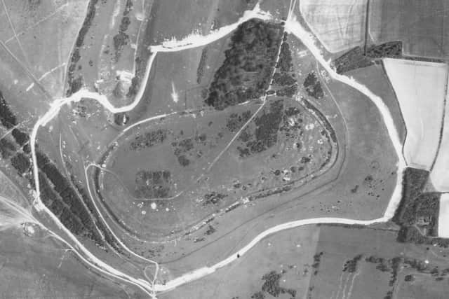
The picture of Cissbury Ring taken on April 22, 1944, shows the anti-tank ditch surrounding the Iron Age hillfort in Worthing.
The ditch formed part of the Findon Nodal Point. Anti-tank ditches and concrete cubes were laid out to impede an enemy advance, northwards through Findon Valley.
Another picture of Worthing taken on the same day shows Worthing Pier with part of its decking removed to make an enemy landing more difficult.
Advertisement
Hide AdAdvertisement
Hide AdDuncan Wilson, chief executive, Historic England, said: “Our USAAF Collection records changes taking place in England as a result of the Second World War, as well as capturing fascinating incidental detail, like American troops playing baseball.
“Our collection of USAAF wartime photographs were taken in England by the pilots and aircraft of squadrons that provided intelligence for the eventual defeat of Nazi Germany. This came at a cost, with many pilots killed in the line of duty.
“We are making these images available to the public for the first time online, giving people access to this remarkable collection of historic photographs. They help to highlight the vital role aerial reconnaissance played in the Second World War.”
Whole towns and large sections of cities are captured in single frames. To find out more about the Historic England Archive’s USAAF Collection visit https://historicengland.org.uk/usaaf
Advertisement
Hide AdAdvertisement
Hide AdWhen the Photographic Reconnaissance squadrons arrived in England, the crews had to learn British radio procedures and flying regulations.
Pilots took photographs during flights over local areas near their bases while gaining the necessary experience to qualify for operations over enemy territory.
Flights were also made to test new and repaired aircraft and camera equipment, as well as to carry out photographic assignments.
The United States of America joined the Second World War in December 1941, following Japan’s attack on Pearl Harbour.
Advertisement
Hide AdAdvertisement
Hide AdTo defeat Nazi Germany, the USAAF and Britain’s Royal Air Force (RAF) adopted a strategy to destroy enemy infrastructure by bombing targets from the air. Britain’s proximity to occupied Europe made it an ideal base for operations.
The first air crews of the USAAF’s VIII Bomber Command - later known as the Eighth Air Force - arrived in Britain in early 1942.
The USAAF established Photographic Reconnaissance (PR) units at airfields in England – like RAF Mount Farm in Oxfordshire and RAF Watton in Norfolk.
Each group consisted of several squadrons, supported by specialist crews that maintained aircraft and cameras, processed films, printed photographs and interpreted the results.
Advertisement
Hide AdAdvertisement
Hide AdAlong with the RAF Photographic Reconnaissance units, they provided vital intelligence by photographing cities, factories, shipyards, military facilities, and infrastructure in Nazi-occupied Europe.
The PR units often used specially-adapted aircraft with guns and weapons removed to accommodate fixed cameras and additional fuel tanks for long-range missions.
Cameras had a range of lenses and focal lengths, so they could capture whole towns and cities in single frames, as well as target specific sites.
They were operated by the pilot with a push-button control and had magazines with rolls of plastic film, with the capacity to take scores of frames.
Oblique photographs captured specific targets, while vertical photographs could be overlapped and viewed through stereoscopes to give a three-dimensional view of buildings and landscapes.