Vision for ‘ambitious’ Eastbourne cycling and walking network


East Sussex County Council’s is consulting the public on its first local cycling and walking infrastructure plan (LCWIP).
The draft document splits the county up into six areas: Eastbourne and south Wealden (including Hailsham and Polegate), Hastings and Bexhill, Newhaven area (including Peacehaven and Seaford), Lewes and South Downs, rural Rother and north Wealden & north Lewes (including Uckfield, Heathfield and Crowborough).
Advertisement
Hide AdAdvertisement
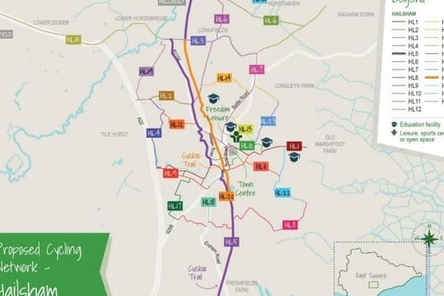
Hide AdProposed cycle network maps have been produced for each of the areas as well as walking network maps for Newhaven, Lewes, Eastbourne, Hailsham, Bexhill and Hastings.
Alongside this is a programme of cycling and walking infrastructure improvements.
These do not contain detailed proposals, but indicate potential alignments of routes or measures, with an emphasis on demonstrating how they can connect with places people may travel for everyday journeys.
The LCWIP ‘sets out an ambitious network of additional cycling and walking routes and measures integrated with existing cycling and walking infrastructure’.
Advertisement
Hide AdAdvertisement
Hide AdThe document adds: “This is set alongside the wider transport network, with the aim to maximise the potential to support new housing and employment space coming forward. This first version of the LCWIP will be focussed on those areas where there are the greatest opportunities to increase levels of cycling and walking.”
The plan says: “In Eastbourne, by taking advantage of an essentially flat topography, routes will support access for localised journeys as well as to support the visitor economy. There is also an emphasis on supporting improved access to the town centre and seafront area.”
The proposed cycling network (strategic routes are in bold) includes: E1 South Downs Way – Sovereign Harbour via Seafront, E2 University – Pevensey Bay, E3 Hospital – Westham, E4 Polegate High Street - NCN21 and A22, E5 Polegate-Seafront, E6 Willindon Road - Seafront, E7 Hampden Park – Sovereign Centre, E8 A22 / Dittons Road - NCN21 – Willingdon Drove, E9 Stone Cross – Royal Parade via Langney, E10 Seaside Road – Sovereign Harbour – Eastbourne Road, E11 Town Hall – Langley Roundabout, E12 Ramsay Way – Route 200 – Pacific Drive, E13 Station – Upper Avenue, E14 Horsey Way – Seaside, E15 Upperton – Eastbourne Park – Sevenoaks Road, E16 Victoria Drive – Hospital, E17 Willingdon Roundabout – South Shinewater Park, E18 Willingdon – The North Shinewater Park – Friday Street, E19 Lower Willingdon - Willingdon Upper, E20 Eastbourne Road - Polegate Recreation Ground - Cuckoo Trail, E21 Dittons Road - Cuckoo Trail – A22, E22 Borough Lane - King Edward’s Parade, E23 Old Town-Library and Council Offices - Terminus Road - Seafront, E24 Rodmill - Eastbourne Rail Station, E25 Coopers Hill – Wish Hill, E26 Hazelwood Avenue and Hampden Park – Eastbourne Station link, E27 Polegate – New North Railway Path – Hampden Park – Ringwood Road - Seafront, E28 Stone Cross – Larkspur Drive – Sevenoaks Road, Friday Street – Pennine Way – Seafront, E29 Friday Street – Pennine Way – Seafront, E30 Netherfield Avenue – Sovereign Harbour - Seafront and E31 Pevensey – Pevensey Bay.
Meanwhile Hailsham’s proposed cycling network includes: H1 Diplocks Way (A22) — Phoenix Academy, H2 Hempstead Lane, H3 Cuckmere Close — Battle Road, H4 Diplocks Way / A22 — Hempstead Lane, H5 Polegate – Hellingly, H6 High Street — Hellingly, H7 London Road — Battle Road — Hawkswood Road, H8 South Road — Mill Road, H9 A22 — Vicarage Lane, H10 Summerheath Road — High Street, H11 Vicarage Road — Hamlins Park Close, H12 Gleneagles Drive — London Road, H13 Battle Road — White House School, H14 Hawks Road — Harebeating Lane, H15 Lower Dicker — Park Gate Road, H16 Hellingly — Park Gate , H17 Arlington Road East — Upper Horsebridge Road, H18 Ersham Road — South Road, H19 Hempstead Lane - Upper Horsebridge Road, H20 South Road Car Park — Upper Horsebridge Road, H21 New Road - The Drive, H22 Mill Lane - Marshfoot Lane and H23 White House School - Harebeating Lane.
Advertisement
Hide AdAdvertisement
Hide AdThe delivery of the plan will rely on the county council and its partners securing external funding and buildings on £23million already secured since 2014 to deliver active travel measures through the local transport capital programme.
Claire Dowling, lead member for transport and environment, said: “Walking and cycling not only improves people’s health and wellbeing, it can help protect the environment and improve air quality.
“Some people have been able to re-think how they travel since the beginning of the Covid-19 pandemic with cycling and walking becoming more of an option. We are keen to put in place infrastructure to support the opportunity to change habits and enable others to find more active and healthy ways to travel.”
In line with guidance from the Department for Transport, the county’s first plan will focus on areas where there is the greatest opportunity to increase levels of cycling and walking and therefore, to attract external funding – this includes the coastal strip and larger market towns in the county.
Advertisement
Hide AdAdvertisement
Hide AdIn rural areas, the council will look at how walking and cycling can be supported through its local transport plan, as well as local and neighbourhood plans. Officers will continue to work with local partners to identify opportunities and funding for active travel.
Cllr Dowling added: “It’s vital that people take this opportunity to comment and help us create a plan that supports active travel and understands the needs of local communities.”
The consultation runs until Friday December 11 and all responses will be carefully considered before a final version of the plan is agreed.
To find out more about the plan and to take part in the consultation, visit https://consultation.eastsussex.gov.uk/economy-transport-environment/escc-lcwip-2020/